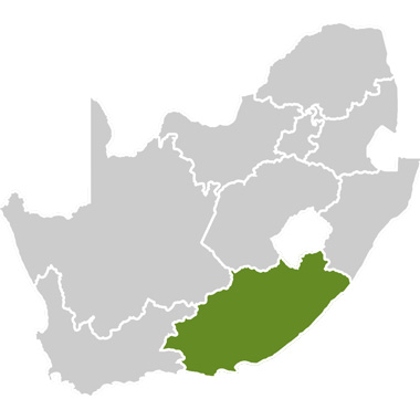
The Thunga-Thunga Extension Route is situated at the heart of the Wild Coast region in the Eastern Cape province of South Africa, in the region previously known as the Transkei.
The general route area starts from the Great Kei River Bridge and Kei Mouth in the south and covers the area all the way up to Port St Johns in the north. It covers a number of rural villages and towns such as Butterworth, Willowvale, Idutywa, Qunu, Umtata, Coffee Bay, Lusikisiki and Port St Johns. The areas are generally linked or joined by the N2 national highway from East London to Durban, with the exception of Ports St Johns, Lusikisiki and Coffee Bay.
Why “Thunga-Thunga Extension”?
The Thunga-Thunga Extension Route derives its name from the original route, the Thunga-Thunga Route, which was launched on the December 1 2000. The name Thunga-Thunga is a Xhosa name, which means “a house with many doors”, of which many have yet to be discovered.
This can be taken literally because the Wild Coast remains a relatively untouched paradise. This rocky stretch with waterfalls tumbling into the sea is the pearl in the crown of the Eastern Cape. From the fisherman’s hideaways to fully serviced hotels, there is a range of accommodation to suit all tastes and budgets.
Landmarks include the centres of Xhosa culture, Umtata and Qunu, the birthplace of former President Nelson Mandela.
Butterworth:
Is one of the oldest towns in Transkei and it traces its roots to the Wesleyan Mission Station, which was established by the Rev WJ Strausburg in 1827 at the kraal of Hintsa, paramount chief of the Gcaleka clan of the Xhosas. The mission station was named after Joseph Butterworth, the treasurer of the then Wesleyan Mission Society that was destroyed during the First Frontier War in 1834, after which the area became the scene of much fighting. In 1877 a magistrate was stationed here and the town plan was laid out in1904, which is when it became known as Butterworth.
Coffee Bay:
This entrancing little village and resort, girded by the mountains and spectacular cliffs that lie between the Bomvu and Nenga river mouths, received its rather exotic name from a disappointingly prosaic incident. It is believed that an old, 19th-century freighter ran aground at the mouth of the lagoon and spilled its cargo of coffee beans, some of which reached shore, and took root there.
Today, though the area is entirely devoid of coffee trees, it does boast an impressive array of natural assets, among them the magnificent coastal scenery. The most dramatic viewpoint involves a fairly steep ascent up a rutted track to mapuzi (place of pumpkins), from which you can see the great sweep of the seaboard and, inland, most of the Transkei region.
Idutywa:
This busy trading and communications centre was founded in 1884 in the valley of the Mputi River on the site of an old military post. The town, which in its early days was the scene of much dissension and several upheavals, is now a prosperous farming centre with numerous trading stations. This is the area where the mother of Thabo Mbeki, the president of the Republic of South Africa, resides amongst her community.
Kei Mouth, Kei River and Kentani:
Situated on the southern bank at the mouth of the Kei River among scenic coastal forests, the Kei Mouth signals the beginning of the Wild Coast proper. At Kentani a tragic battle was fought on February 7 1878, during the Ninth Frontier War. A force of about 5000 Xhosa warriors attacked a garrison of almost 1000 European and Fingo soldiers.
The Xhosa had been told by Xito, one of the most famous of all African diviners, that the soldiers’ bullets could not harm them. Urged on by their two great chiefs, Kreli and Sandile, they charged into the hail of bullets and were mown down. More than 300 Xhosa were killed for the loss of only two government soldiers. What was left of the Xhosa force fled south of the Kei River with Sandile. Kentani is now a small but charming trading centre.
Lusikisiki:
The wind whispering through the marsh reeds at dusk is said to make the sound “lusikisiki” and this is the name given to the village that has grown up near the marsh and which is now the capital of Pondoland. It is a pleasant place with its single main street full of trading stores and government offices. Look out for the Magwa Falls, and the tea plantations in this area.
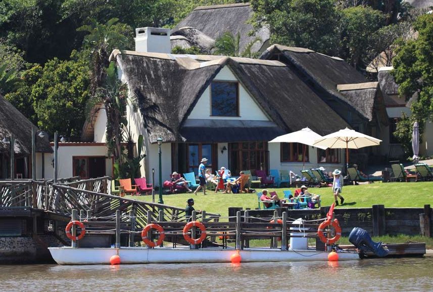
Port St Johns:
Port St Johns stands where the Mzimvubu River reaches the sea between Mount Thesiger and Mount Sullivan in a majestic setting of tremendous cliffs densely covered in sub-tropical forest. The port takes its name from a Portuguese ship, which was tragically wrecked in 1552, a short distance up the coast. Roadside stalls sell fruit and beautifully made mats, baskets and curios.
The area is a drowsy easy-going place with three superb beaches, several rocky headlands, excellent boating up the river and many paths leading through the forest. The climate is perfect for holidays throughout the year with sea temperatures high enough for even midwinter swimming. In the river valleys, bananas, paw paws, mangoes, litchis and avocados grow.
Port St Johns has always been the home of outlandish characters, none more colourful than Huberta, the famous wandering hippopotamus.
The Great Trek of Huberta the Hippo:
The wandering hippopotamus, Huberta, who started a great trek across South Africa in November, 1928, is the star exhibit at the museum in King Williams Town. She spent three years covering about 1600km, wandering from Richards Bay in KwaZulu-Natal as far as the Keiskamma River near King Williams Town in the Eastern Cape.
During her long journey, she munched her way through gardens, gate-crashed parties, knocked down fences, overturned boats, trampled golf courses and wallowed in lagoons. Initially christened “Hubert” by the media, she was promptly renamed Huberta when her gender became obvious!
During a visit in northern Natal someone decided she’d make a good mate for a lonely hippo in the Johannesburg Zoo, but the lady was not in favour! She ran for it, charging aggressively and chasing people up trees. Afterwards she was proclaimed royal game, photographers followed her, the media wrote about her journeys, and she attracted many fans.
Huberta’s next stop was Durban, munching her way through sugar cane fields, trampling over gardens, then wallowing in the lagoon at the mouth of the Mlanga River for a season. Then Huberta set off again, this time into Durban itself. She waddled through golf courses, housing estates and even gatecrashed a party at the Durban Country Club by appearing on the verandah among the partygoers! Realising she was unwelcome there, she charged off, crashing through fences and fields. On a stroll into town, she paid the local chemist a visit.
Huberta was admired by all cultures: Indians sacrificed a goat in her honour, Zulus believed she had a connection to their leader Shaka, as she often visited Zulu pools, and the Pondo people of the Wild Coast believed she was a reincarnated legendary diviner.
In 1930 Huberta had reached Port St Johns, where she promptly began grazing in gardens and overturning boats, much to the amusement of some. She stayed here for six months, and then wandered on. By March 1931 she had reached East London where she made it to the Keiskamma River where, sadly, three hunters shot her. After a national outcry, the hunters were caught and pleading ignorance, were fined the equivalent of R25. Experts recovered her body and took her back with them to the museum, where she can be seen
Willowvale:
The village of Willowvale takes its name from the wild willows growing in the valley in which it lies. It was built as an administrative centre for the Gcaleka people and the seat of their paramount chief is nearby. The road through Willowvale leads on to Qora Mouth and Nqabara Point on the Wild Coast.
The Gcaleka Tribe (Xhosas) during 1827 came from Mbashe and settled in Nqadu, presently known as Willowvale. Mnxiwa, the then king of the Gcaleka, was the first person to settle there. His brother, Gwebinkumbi, followed him and settled in the same area. The present king is Xolilizwe Sigcau.
Even to this day, the Gcaleka Tribe dominates the area. They still live in mud houses although some are modernised and are built with cement rather than mud bricks. The Xhosa culture is still dominant in the community and red traditional blankets are still worn by the older women in the area.
Umtata:
The name Umtata first came up in 1688 from Umtata River, where it is believed that the Tembu people had a custom of interning their dead by casting them into the river with the entreaty “Mthathe Bawo” ie “Take him/her, Father”. Therefore, the noun Umtata was born out of the verb Mthathe. Umtata had its beginning in 1869 as a military buffer between the warring Pondo and Tembu peoples, and 10 years later a village had grown up behind the walled enclosure.
The University of Transkei was established here in 1976 as a branch of Fort Hare University. In 1977 it gained its own identity. The university is popular for its faculty of medicine.
St Johns Cathedral is over 100 years old is one of the most attractive buildings to see in the area.
Umtata Museum was once known as the National Museum of the Transkei Homeland, and is housed in the old Umtata Post Office building. The museum focuses on the cultural and natural history of the Transkei, including local birds, mammals, geology, and archaeology. The Joan Broster Beadwork Collection was part of the founding collection of the museum.
Nduli Nature Reserve is situated in a valley on the outskirts of Umtata; the entrance gate is only about 3km south of Umtata on the main East London road. The reserve is only open to day visitors. Acacia caffra and Acacia karoo are the most abundant tree species. Sombre bulbuls, fiscal flycatchers, black-crowned tchagras and yellow-eyed canaries are common in the thorn bush, and several species of swallow and swift occur here too.
The National Museum:
The National Museum dates back to 1929 when it was known as the “Bhunga Building” for parliamentarians during the former Transkei “homeland”. Now it has been turmed into a museum in honour of one of the South Africa’s greatest sons, Nelson Mandela. The museum has three nodes: Mvezo, dealing with his birthplace, Qunu where he grew up, and Umtata, where the museum is located.
The three Historical sites of the National Museum: Bunga Building, Qunu and Mvezo:
The Bhunga Building has three wings – the first is dedicated to the countless honours bestowed upon Madiba, the name by which Nelson Mandela is fondly known; the second to the thousands of gifts ranging from delightful artworks from children to more illustrious gifts from heads of state the world over; and in the third wing, named “Long Walk to Freedom”, you will hear the whole story told through Mandela’s own words, illustrated with images captured largely through the lenses of previously banned photographers. These fragments of history are brought to life with rarely heard interviews with Mandela and other liberation leaders.
At Qunu you will experience the way Mandela lived as a child – running with cattle, sliding down gigantic granite rocks, and swimming in the stream sparkling in the valley below. Qunu is the village to which Mandela’s father relocated after being deposed as Mvezo chief, where Mandela built his retirement home, holds Christmas parties for children, and where the members of his family are buried.
Somewhat further off the beaten track you come to Mvezo, where little has changed since Mandela drew his first breath here on the July 18 1918. Whether you choose to wander the footpaths he used to use, stand in the remnants of what was once his family homestead, or simply admire the magnificent view, Mvezo promises an unforgettable experience.
Some Messages from Nelson Mandela:
On education:
“Education is the great engine of personal development. It is through education that a daughter of a peasant can become a doctor…the child of farm workers the president of a great nation. It is what we make out of what we have, not what we are given, that separate one person from another.”
There was not one moment
“I cannot pinpoint a moment when I became politicised, when I knew that I would spend my life in the Liberation Struggle. To be an African in South Africa means one is politicised from the moment of one’s birth, whether one acknowledges it or not – I had no epiphany, no singular revelation, no moment of truth, but a steady accumulation of a thousand slights, a thousand indignities and a thousand unremembered moments that produced in me an anger, a rebelliousness, a desire to fight the system that imprisoned my people.”
Qunu was a place of rolling hills
“Nature was our playground – the hills around Qunu were dotted with large smooth rocks which were transformed into our own roller coaster – I do not remember a moment where I was lonely.”
Mvezo
“I was born on 18 July 1918 at Mvezo, a tiny village on the banks of Mbashe River in the district of Umtata. Mvezo was a place apart, a tiny precinct removed from the world of great events, where life was lived much as it had been for hundreds of years.”
My journey has not yet ended
“We have not taken the final step of our journey, but the first step on a longer and even more difficult road. For to be free is not merely to cast off one’s chains, but to live in a way that respects and enhances the freedom of others. The true test of our devotion to freedom is just beginning.”
The nation that committed suicide:
There is a pool in the Gxara River that is filled to overflowing with terrible memories, for it was here that the strange predictions of a 14-year-old girl called Nongqawuse virtually led her people committing suicide. One day in 1856 Nongqawuse was sitting on the rocks above the pool looking down into the water, when she fancied she saw the faces of her ancestors.
Nongqawuse told her people, the Gcaleka, that the ancestors were prepared to return to Earth to drive Europeans from their country. But first as an act of faith to prove their belief in the world of the spirits, the Gcaleka would have to kill all their cattle and destroy all their crops. Those who refused would be turned into frogs, mice and ants and would be blown into the sea by a mighty whirlwind.
For 10 months a kind of madness possessed the Gcaleka. They killed their livestock and destroyed their crops until they had nothing left but faith. The day of their salvation was to be February 18 1857. On that day, Nongqawuse predicted a blood-red sun would rise, stand still in the sky, and then set again in the east.
As the great day dawned, the Gcaleka people sat waiting. The sun rose. It made its slow passage across the hot February sky. A breeze blew out of the sea as the sun set in the west. Darkness fell on the ruined people. About 25000 people died of starvation. Others survived only through the help of neighbouring communities and Europeans.
As for Nongqawuse, the deluded people would have torn her to pieces but she fled to the King Williams Town area to find safety with the British. For her own safety she was kept at Robben Island and later spent the rest of her life on a farm in the Eastern Cape. She died in 1898.
Travelling to the Eastern Cape:
By air, fly directly to one of the three international airports, Johannesburg, Cape Town or Durban. Catch daily connecting flights to the regional airport situated in Umtata. SA Airlink services this route. The main regional airport is East London Airport, which is accessible from most major South African cities. East London is a beautiful, safe, three-hour drive from Umtata.
Travelling by road, one can either take a coach or do a self-drive trip. South African roads are known to be amongst the best by world standards and the Eastern Cape province is one of the most scenic regions in the country and makes for an unforgettable holiday experience. Some roads, however, are unfenced; so be careful of wandering animals – especially at night.