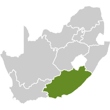


East London:
East London is South Africa’s only river port, situated along the banks of the Buffalo River. The city has a rich cultural heritage, with historic buildings dating back to the 19th century.
It is a popular destination as the gateway to the Wild Coast to the east and the Sunshine Coast to the west, and in itself is an attractive destination with beautiful beaches and a friendly atmosphere.
A wide range of holiday accommodation for all seasons is available. East London’s temperate climate makes it a sought-after venue for hosting international and national sporting events. Its natural beauty aside, the city is also an important industrial centre. Key industries include motor assembly, sweet manufacturing, electronics, citrus, textiles, pineapples and wool.
King William’s Town and Bisho:
King William’s Town grew out of the Buffalo Mission Station, founded in 1825 by John Brownlee. The N2 road leads through a magnificent rural landscape to this historical town which was named after King William IV of Britain. During the Xhosa Wars (a series of nine wars also known as the Cape Frontier Wars, fought between the Xhosa people and European settlers from 1779-1879) about 2000 German legionnaires settled in the area to strengthen settler defences. There are a number of interesting monuments and museums to see in the town.
Bisho, which means ‘buffalo’ in isiXhosa, is the Eastern Cape’s capital city, and is situated 8km east of King William’s Town. During the apartheid era Bisho was the capital city of the former bantustan, Republic of Ciskei.
The Bisho Massacre occurred on September 7, 1992, in Bisho. About 30 people were shot by members of the Ciskei Defence Force during a protest march in which they were demanding Ciskei’s reincorporation in South Africa.
Debe Nek:
Debe Nek is a railway station with a post office and bus halt on the line from King Williams Town, situated 19km from King William’s Town on the road to Alice. The name refers to the channel through which the Debe River flows.
A great battle between rival Xhosa chieftains Ndlambe and Ngqika, called the Battle of Amalinde, took place at Debe Nek in 1818.
This is where the giant earthworms occur. The region east of Debe Nek is known in Afrikaans as Kommetjievlakte (“the plain of the little saucers”). The landscape here is dotted with thousands of depressions formed by giant earthworms – a zoological curiosity of the area. These creatures of the Microchaetus genus can grow to more than 3m in length and are so active that their burrowings create mounds and hollows.
Alice:
This town is situated on the banks of Tyume River, east of Fort Beaufort, and was founded in 1824 as a mission station for the Glasgow Missionary Society and named after Princess Alice, Queen Victoria’s daughter. It is an important educational centre in the Eastern Cape and home to the University of Fort Hare and Lovedale College. Mohair, wool, citrus fruit, timber, tobacco and livestock are the main economic activities in this agricultural district.
Healdtown:
Healdtown is a Methodist mission station located 11km from Fort Beaufort. The Rev John Ayliff founded the station in 1853 for the Fingo clan, on what had been the site of the Birkland Mission Station of the London Missionary Society, founded by Rev Henry Calderwood in 1844. The school of industry was established in 1855 and a training institution for teachers and theological students in 1867 with the help of James Heald of Manchester. Because of Heald’s generous contribution, the station was named after him. The Bantu Education Act of 1953 transferred these schools to the state.
Balfour:
This village at the bottom of Katberg is dominated by the Didima mountain range. It was founded as a mission station in 1828 and named in honour of Robert Balfour, the first secretary of the Glasgow Missionary Society. Balfour is a commercial centre, known for its citrus and tobacco grown under irrigation.
Hogsback:
Perched on the slopes of the Amatola Mountains, Hogsback is a little piece of England on the African continent – complete with seasonal changes and snow. The surroundings with their mystical aura demand exploration, as does the lifestyle of the people who have found sanctuary there, opting out of the pace of mainstream living in exchange for a quieter, gentler existence.
The town’s name comes from the ridge on which it is situated, which resembles the bristles on a hog’s back. Because of its elevation and commanding position on the ridge, it is shrouded by constantly changing cloud formations, giving it an air of magic and mystery. Not surprising, therefore, that JR Tolkien, renowned author of The Lord of the Rings and The Hobbit, who was born in South Africa and who often visited the area, was so inspired by the seemingly endless ancient forests, cascades of waterfalls and gentle streams that he reflected them in his stories.
Cathcart:
The area was named after Sir George Cathcart who was the governor of the Cape from 1852 to 1854 – and had ended the Eighth Frontier War between the Xhosa and the settlers. It was originally a military stronghold on the slopes of Windvogelberg (literally translated, “Wind Eagle Mountain”, named after a chief of the San (Bushmen) who used to live in these parts. Now its excellent hill slopes make it a popular area for gliding.
Stutterheim:
Stutterheim is situated on the R30 on the forested slopes of the Kologha Mountains between Cathcart and King William’s Town. It was founded in 1837 by soldiers disbanding from the British German Legion, who named it after their general, Richard von Stutterheim. The town is a centre for citrus fruit, sheep, dairy and beef production, as well as forestry.
The turn-off to the grave of Sandile, who was the warrior chief of the Gaikas killed in June 1878 during the Ninth Frontier War, lies 6km south of the town. North of the town lies the Bethel Mission, built in 1865 on the site of the first Berlin mission station in the Eastern Cape.
Keiskammahoek:
Keiskammahoek is located on the Keiskamma River (meaning ‘shining waters’ in Khoi), 32km north-west of the railhead at King William’s Town. It also lies 19km north-east on the road from Middledrift to Stutterheim. Keiskammahoek was founded in 1855 as a frontier post, after the Seventh Frontier War, also called the War of the Axe. The war ended here with the surrender of the two chiefs, Sandile and Maqoma, in 1847. The original inhabitants of the area were the Bushmen who were driven out by Gaika and his Rharhabe Xhosa tribe. The town used to be the seat of the Bantu Affairs Commission for the Ciskei during the apartheid era.
Berlin:
Berlin is situated amid the grass-covered hills on the N2, between East London and King William’s Town. It was founded in 1857 by soldiers under Count von Lillienstein and Lt Col Von Hacke who disbanded from the British-German legion, later fought for the British during the Seventh Frontier War and stayed on afterwards. Berlin was named after the German capital city, and there are many other small villages in the area that were settled by Germans and nostalgically named after German towns, such as Stutterheim and Hamburg.
Kei Road:
It is a village situated 27km north-east of King William’s Town on the road towards Komga and also on the railway between East London and Queenstown in the King William’s Town district. It was given this name because of its position on the military route between Kei River and King William’s Town.
Komga:
The village of Komga also has its origins during the frontier wars of the 19th century. Situated in fertile grassland along the R63 just off the N2 highway, the name means ‘place of clay’. Today it is a centre for cattle and sheep farming. Nearby there is a memorial at Draaibosch to Col. Hans Garrett Moore of the Connaught Rangers, who was awarded the first Victoria Cross on South African soil was for his conduct during the Ninth Frontier War of 1877 when he led a patrol against Ngqika’s Gaika warriors on 29 December 1877. Fortunately, he only sustained an arm wound. The memorial also recognises the bravery of Sgt D Harber and Cpl J Court in the same encounter.
Kei Mouth:
Situated on the southern bank at the mouth of the Kei River, with the scenic coastal forests, the Kei Mouth signals the beginning of the Wild Coast proper.
Morgan Bay:
The resort and hotel have grown around the spot that was named after AF Morgan, sailing master of the royal navy ship Barracouta, in which Captain WF Owen surveyed the coastline in 1822. The Great Kei River in the north and Ntshala River in south form the beautiful lagoon at Morgan Bay’s and two other rivers reach the sea within few kilometres of one another along this scenic coast. The abandoned workings of the Cape Morgan titanium mine, which was first exploited in 1958, still remain. Rare shells and fragments of ancient Chinese porcelain from old shipwrecks are sometimes found washed up on the beach.
Haga-Haga:
Haga-Haga is a village and hotel of the same name, situated at the coast about 70km from East London, and facing out to the sea from the bottom of two hills. The beach at the river mouth is good for fishing and provides a good area for shell collecting. The area is managed as a conservancy, which protect a number of rare species, such as the blue duiker and the Cape clawless otter.
Cintsa:
Cintsa comprises a complex of resorts overlooking Cintsa Bay and a lagoon which can be used for various water sports all year round.